El Kharaba is a deserted piece of land where djins and creatures of the night dwell and thrive in the dark. Commonly found in urban neighbourhoods, el kharabat1 (plural for kharaba) are integral components of urban ecologies. They are convenient dump-sites particularly for obsolete pieces of furniture, open defecation spots, places for striking illicit deals and shelters for stray dogs, animals and occasionally, the homeless. Before the real estate frenzy of the 21st century gripped Cairo, it was common to find kharabat in several middle-class urban neighbourhoods. Back in the sixties and seventies, it was not necessary to wall them. Police departments could easily manage them without walls, and municipalities could relatively easily re-claim them for public purposes if they were not in legalised private ownership.
After the 1967 Naksa (‘day of the set back’) defeat in the Israeli-Egyptian war, the destruction of most Suez Canal cities, and the Israeli occupation of the Sinai Peninsula, Cairo’s local municipalities, among other state authorities, could no longer sustain urban services. A phenomenon of arbitrary claiming of empty lands in urban and rural areas thus broke out. While in some neighbourhoods such ‘hand-claiming’ of a kharaba could have stirred public scrutiny, the situation on the peripheries of dense neighbourhoods was comparably lax. It was during this time that Egypt came to know of unplanned settlements, or what is officially known as ashwaiyat (arbitrary or haphazard settlements).
Whereas privately owned kharabat in planned neighbourhoods were usually put into use as high-rise apartment buildings or transformed by municipal authorities into shelters for disaster-stricken populations, El kharabat on the peripheries of the city and the ones inside historic quarters had entirely different fates. El Hattaba is an example of the latter that stands out in distinction especially in the manner of how historic ruins are appropriated, re-appropriated and contested by residents, tourists, security forces, municipalities and the media, and in how the concept of ruins and of el kharaba is re-interpreted over time.
El Hattaba is an old neighbourhood adjacent to Saladin Citadel – one of Cairo’s prime Islamic monuments. El Hattaba dates to the 12th century and is part of UNESCO’s 2012 Urban Regeneration for Historic Cairo Project. It houses around 372 buildings, between residences, crafts workshops, heritage monuments and almost 1600 households that currently live and work in the neighbourhood. In fact, UNESCO ranks it (1A) in its classification of historic areas in need of urgent safeguarding.
Nevertheless, its location adjacent to the Citadel places it inside the monument’s buffer zone, where renovations, demolitions or constructions are prohibited by law. In fact, the law permits the Ministry of Antiquities to alienate lands and buildings in the area if deemed necessary for safeguarding the Citadel, or any monument for that matter.
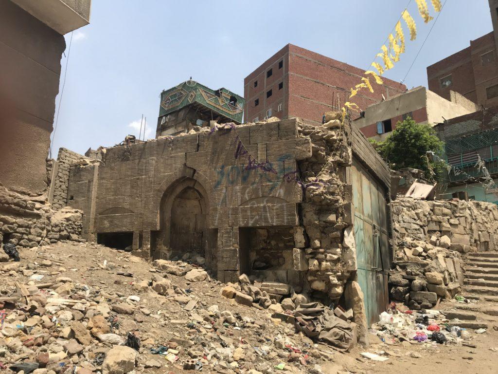
Regardless of intentions, this law holds El Hattaba hostage and actively contributes to the deterioration of its buildings and open spaces, including the architecturally unique ones as indicated by the photo above. Over the years, since the law took effect, residents have not been able to maintain or renovate their houses or workshops. Ethnographic conversations with residents revealed that they do not even clear the waste they throw in open spaces for fear of indictment for illegal excavation of relics within a heritage buffer zone. Further, the limited financial capacities of Darb El Ahmar district authorities, where El Hattaba falls, make waste and garbage collection take place quite erratically and not without bribes. This legal predicament – regardless of UNESCO’s stipulations – incessantly ruins the site. It reproduces the entire area into one large kharaba, with detrimental effects on health and wellbeing.
Economically, El Hattaba has been remanded since 1996, when, in response to a spate of terrorist attacks on tourists in Cairo and elsewhere, the national security forces closed the Citadel’s New Gate – the gate that opened unto the area and was the main source of tourism due to its diverse historic craftsmanship – a situation that resonated with Ann Laura Stoler’s apt argument, quoting the Oxford English Dictionary: “to ruin is to inflict or bring great and irretrievable disaster upon, to destroy agency, to reduce to a state of poverty, to demoralise completely” (2008: 194)2.
Nevertheless, in the immediate aftermath of the 25th January uprising, and in the absence of police and municipal controllers, few residents swiftly constructed new residential buildings (like the mud brick building in the photo above) and renovated old ones, using their own expertise, funds and labour. The mismatch of design, construction material and land use between the renovated buildings and the urban fabric of older ones gives a unique contemporary aesthetic to El Hattaba; one vehemently opposed to the Ministry of Antiquities field surveyors.
This mismatch was also behind enlisting El Hattaba on the National Map of Unsafe Areas issued in 2015 by the Informal Settlements Development Fund (established in 2008 to upgrade or remove ashwaiyat). Following the Fund’s Map, a Cairo Governor’s decree slated El Hattaba for ‘redevelopment’. In no document to date, however, has the Fund or the Governor ever defined ‘redevelopment’ in any operational terms.
Amidst absence of clarity, in October 2018, the municipal authority of Darb El Ahmar conducted a census of the area in preparation for eviction and demolition. Censuses of this sort almost always stir negative community sentiments and are harbingers of fragmentation. The government has often used ‘proof or lack of legal tenancy’ to pressure households into accepting eviction, settling down for low monetary compensations or relocation to distant under-serviced sites on lease. Presenting the community with multiple options undermines solidarity against the ‘external’ threat. In El Hattaba, this was accomplished by stealth. Even before the latest census, rumours spread that only houses within a 50-meter parameter around the Citadel would be demolished. The perimeter was later expanded when news of community mobilisation reached the municipality. This eventually dissipated efforts to stand up against pending demolition.
Nevertheless, there are other forms of resistance emerging. In 2017, in response to rumours about forced eviction and in response to the protracted, state-instigated process of ruination targeting El Hattaba, Mohammed Khalifa, a young man from the neighbourhood released a YouTube rap song that accused the government of stigmatising El Hattabawith the intention to sell the area to private developers and capitalise on its real-estate value. The song boasted of the area’s ruins, its dilapidated buildings and kharabat open spaces. Although a hit among interested urbanists, the lyrics and performance by Khalifa gave away the sense of anxiety and demoralisation, of uncertainty, despair and belligerence among residents, all at once.
Beyond despair, the YouTube song has brought El Hattaba to the attention of urban enthusiasts who are slipping through the cracks of state policies and are presently lobbying for the enactment of adaptive reuse of heritage ruins, among other strategies, in full participation from the youth of the area, in a process that could be conceived of as counter-ruination. The battle over El Hattaba is underway. Both urbanists and few community members are teaming up to design in-situ upgrading. However, the strategies of the warring factions remain reactive and ad hoc.
For eviction to stop being the most preferred off-the-cuff policy, sympathetic urbanists need to work on four fronts. Lobbying at ministerial and governorate levels to ensure minimal degrees of support to alternative urban regeneration plans. In the case of El Hattaba, the Built Environment Collective, active in heritage conservation presented a detailed conceptual plan for urban regeneration of the area in October 2018. The plan received prima facie blessing from the permanent committee of the Ministry of Antiquities. Nonetheless, the blessing was a non-starter for Cairo Governor, who ordered the pre-eviction census in the same month.
Besides lobbying, urbanists need to harp on the, otherwise, eroding sense of community and mobilise for collective initiatives. Something that the Built Environment Collective and few others are actively pursuing albeit without integrating the financial capacities of community members. There is generally a misconceived notion that residents of unsafe areas are poor. While many are indeed in abject poverty, several others have the means to construct their own dwelling units and would stand to lose with eviction and relocation. This common threat could motivate them to invest in a collective fund with technical and managerial support from urbanists who are predominantly funded by international organisations. This is by no means a call for designing neighbourhood participatory budgets. It is rather a step towards tapping the financial capacities of residents of the so-called ‘unsafe’ areas of Cairo.